


ExynAI is a proprietary LiDAR-based SLAM algorithm that enables Nexys to autonomously navigate unstructured, GPS-denied environments while simultaneously capturing a feature-rich, colorized digital twin that can be rendered on the same tablet used to plan missions.
Built from the ground up to be platform agnostic and open to 3rd party data streams, ExynAI is a mobile SLAM platform that works out of the box and when given time in the field can evolve into a useful tool in the modern surveyors toolkit.
Learn More about SLAM
Our proprietary autonomy algorithms, coupled with our SLAM-based LiDAR scanning technology deliver survey-grade 3D models without a pilot.
Leveraging Autonomy Level 4B, the operator simply sets the area to scan and the system determines its own route to ensure complete environmental coverage, creates a feature-rich 3D model of the entire environment, and identifies and reasons about dust, obstacles and high-level objectives -- even in GPS-denied, hazardous, and un-illuminated environments.
Learn More about Autonomy Levels
Exyn’s technology is designed to perform in the most demanding conditions:
Precision Mapping: Generate survey-grade 3D maps in real-time, even in GPS-denied or signal-limited environments.
Robust Localization: Reliable and accurate localization performance across challenging environments, including GPS-rich, GPS-denied, high-speed, and complex 3D settings.
Proven Field-Ready Autonomy: Validated across hundreds of deployments and tens of thousands of flights, with demonstrated resilience and reliability in diverse and challenging conditions, including dusty environments and obstacle-rich terrains.


Adding an aerial autonomy license opens up a whole new world of 3D spatial mapping. This package comes with the Drone Link accessory to integrate Nexys onto approved robotic airframes for autonomous aerial mapping missions. The autonomy package comes with all the features from the Standard Mapping Package, plus:
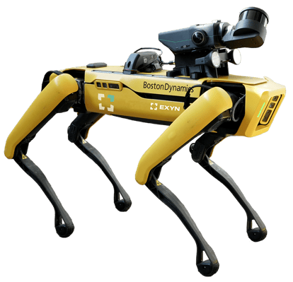
The ground autonomy package for Nexys enables survey teams to explore and map complex environments using an autonomous four-legged robot like Spot, from Boston Dynamics. ExynAI'a autonomy can automate scanning, inspection or as-builting, perform routine inspections, warehouse operations monitoring, convergence monitoring, post-blast safety evaluations, or to remove people from difficult or dangerous mapping situations.
This package comes with the Drone Link accessory to integrate Nexys onto approved robotic platforms. The ground autonomy package comes with all the features from the Standard Mapping Package, plus:

Autonomy anywhere! The combo autonomy package for Nexys enables survey teams to explore and map complex environments using a variety of robotic platforms including drones like the DJI, and ground-based robots such as Spot from Boston Dynamics.
Autonomy licenses are an optional Nexys add-on, SLAM mobile mapping functionality is still fully operational with the choice to add autonomy at a later time.

With the Nexys ecosystem, you can choose to use our AL4B autonomy on a drone or terrestrial robot, or you can select a mapping-only solution depending on your requirements.
We make it easy to start with a mapping-only solution, then, if your needs expand to require autonomy, you can license the software quickly and easily with no downtime.


Powered by ExynAI, Nexys can be deployed onto a drone, ground-based robot or simply carried by hand to capture an accurate, feature-rich 3D model of almost any environment. Capture up to 1.92 million scan points per second at up to ±1cm @ 1 sigma, while continuously updating the map as new data is received.
download accuracy whitepaper

Achieve faster, safer, and more precise point cloud collection -- even in the most complex environments. The Trimble DA2 seamlessly pairs with Exyn Nexys to unify underground and surface-level scans into a single, georeferenced dataset -- eliminating the need for ground control points and accelerating post-processing workflows.
Learn More


