Exyn Nexys

A completely modular 3D mapping solution designed to reduce time to capture, increase safety, and drive efficiency for challenging, complex, or dangerous environments.

Nexys-1-sm
why nexys?

The most advanced autonomous navigation - when you need it

Proprietary autonomy algorithms, coupled with SLAM-based LiDAR scanning technology deliver survey-grade results without a pilot - even in GPS-denied, hazardous, and unilluminated environments. Start with mapping only, then upgrade to full autonomy when you need it. 

Nexys-M350-Exyn-Office-sm
The right scanning tool for all your needs

Rugged and Configurable

Nexys can be quickly and easily switched between a variety of configurations - handheld, backpack, aerial robot, terrestrial robot, vehicle, pole, custom configurations. Built to IP67 standards, users have the flexibility and cost efficiency to use one device in any mapping environment.

Nexys-backpack-construction-sm

Fast Capture, Survey Grade Accuracy

Nexys’  SLAM-based spatial mapping delivers consistent and repeatable survey grade accuracy of up to ±1cm @ 1 sigma at up to 1.92 million scan points per second while continuously updating the map as new data is received. 

Learn More About SLAM
office-colorized-point-cloud-header
Before you leave the field

See Your Scans in Detail

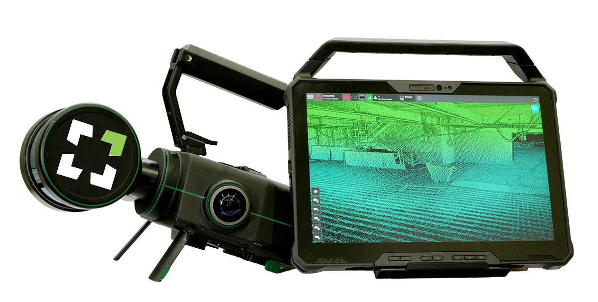
Capture and post processing is done in the field, allowing for real-time visualization of your captured data with full detail and colorization to ensure the scan area is correct and complete before you leave the site. 

explore exynview
office-building-1
Point Cloud Gallery

Sample Datasets

Interact with feature-rich sample datasets captured with Nexys and processed through ExynAI, our proprietary SLAM algorithm, for maximum accuracy. View and download in las file format.  

View & Download

Nexys Feature Set

onboard-intelligence
ExynView Software
Controls capture and post processing in the same system, allowing for fast on premise processing for more streamlined workflows. Creates clean, georeferenced point clouds automatically with additional processing and filtering, and data interoperability into third party software applications.
Check mark
Built to IP67 standards
The highest protection against water and solid ingresses, such as windblown dirt and other airborne solid materials, as well as water hoses, jet sprays, and momentary water immersion. Guaranteed to function in indoor, outdoor, wet, and demanding industrial and commercial settings.
multi-spectral-sensors
Real-Time 360º Colorization
Hemispherical cameras cover 100% of the field of view of the LIDAR making it easier to generate fully colorized clouds without any additional hardware or cost. Derive additional insights from point clouds with accurate colorization visualization at no additional cost.
modular-software
Modular Design
Robots powered by Nexys' autonomy can perform autonomously in dangerous environments. And then the payload can be detached for manual mapping to capture a complete 3D model.
self-contained
All Intelligence Onboard
Designed to operate beyond visual line of sight, Nexys can autonomously navigate complex, dynamic environments without the need of a prior map, GPS, or any existing wireless infrastructure.
lidar
Real-Time Object Avoidance
With an onboard SLAM engine, robots powered by Nexys autonomy adapt to dynamic environments, detect & avoid obstacles, adjust to sensor failures, and navigate obstructions like thin wires or people, all in real-time.
New-tablet-sm

Small, Light & Powerful Ruggedized Tablet

The Nexys comes paired with a ruggedized Dell Latitude tablet for easy mission planning for autonomous aerial exploration missions, or for monitoring the real-time status of a mobile mapping 3D capture - making mobile surveying simple, efficient, and accurate. 

explore exynview