


When designing a new piece of critical infrastructure, architects will need a clear and precise view of their working environment to ensure the project's success from the very beginning. Using the Exyn Nexys, survey teams tasked with mapping sometimes large and inaccessible areas can quickly and easily capture complex data sets while significantly enhancing the efficiency and effectiveness of geospatial surveys.
Capturing colorized point clouds in real time, surveyors can instantly see areas of their 3D models that need more coverage to ensure a complete picture of the project for the entire team. And once that 3D model is captured, it can be quickly georeferenced and exported via our ruggedized tablet directly into a BIM workflow.
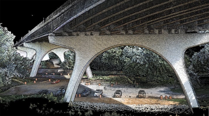
During an emergency, time and situational awareness for first responders is paramount to save lives. Equipped with a modular 3D mapping payload like the Exyn Nexys, surveyors with response teams can quickly create realistic 3D models of dangerous environments for evaluation of potential entry and exit points, as well as areas to avoid and search for potential survivors.
If the area is relatively safe, operators could easily map an area by hand. But in the immediate aftermath of an event, the Nexys can be mounted onto an integrated drone for autonomous exploration and mapping of a complex, dangerous environment. Flying BVLOS without the need of constant communications or a pilot in the loop, first responders can stay focused on the recovery and leave the mapping to Nexys.
While many think 3D SLAM mapping platforms are best suited for outdoor or underground environments, systems that can operate in GPS-denied environments have been proving particularly helpful for urban planning in dense, downtown environments. Capturing rich, colorized 3D point clouds, the Nexys is a crucial tool in any modern surveyors' toolkit.
Once a 3D model is captured, it can be easily georeferenced and exported onsite via our ruggedized tablet and loaded into a variety of geospatial software for further analysis. This is crucial for urban planners to analyze current conditions, simulate changes, and assess the impact of any potential developments. These detailed and accurate maps are also helpful in identifying potential risks for urban areas such as flooding or structural vulnerabilities.
Sometimes it feels like a construction project is taking forever to complete, but when you're on site daily you know how much change happens all around you. Trying to keep track of what areas are under development, environments that need rework or evaluation, and having to report all of that progress to stakeholders is a challenging task for any project lead.

Equipped with a mapping payload like Nexys, survey teams can quickly and easily map entire construction sites as easily as walking through it. They can monitor data capture in real time via a ruggedized tablet to ensure total coverage as well as downsample, smooth, and georeference survey-grade point clouds directly on site without worrying about excessive rework.
Incredibly, individual surveyors are being asked to identify, catalog, and manage a growing number of physical assets over a wide area.

This is particularly useful for industries managing extensive infrastructures, such as utilities, transportation, and urban planning, where accurate location and condition information of assets is crucial for efficient operation and maintenance.
Exyn Nexys effectively conducts thorough surveys and intricate mapping of dense forest environments. This plays a pivotal role in crucial projects, such as monitoring the health of forests, assessing timber resources, and strategizing sustainable forestry practices.

Notably, Nexys has the exceptional capability to autonomously guide robotics through areas of forests deemed inaccessible or hazardous, thereby providing unprecedented visibility and insightful information.