
After a decade of maturity, SLAM-based mobile surveying platforms have evolved into an essential and invaluable tool in every surveyor’s toolkit.
A major reason for this shift has been the increased accuracy of mobile surveying using a variety of internal technologies that automatically correct for drift and global inaccuracies. The result is that mobile surveying using systems like Nexys can consistently provide georeferenced point clouds with accuracy to within ±1cm or less, even in the most challenging environments.
In a recent webinar, Exyn’s Lead Project Manager explained the technology that’s making mobile SLAM an essential tool for surveyors in every industry. We break down the key points from the webinar below, but you can watch the full video with a customer Q&A session right on our website.
As a surveyor, you’re already well aware of how many areas that require mapping are in and around challenging environments. These areas can have safety concerns, cover large areas that stretch your team thin, or have line-of-sight issues, such as heavily forested areas.
All of these situations create roadblocks for traditional terrestrial surveying methods. Deploying and repositioning teams in these situations is time-consuming and sometimes even hazardous. With the addition of a mobile SLAM-based unit to their toolkit, capturing the necessary data while in these challenging situations can be done quickly and efficiently.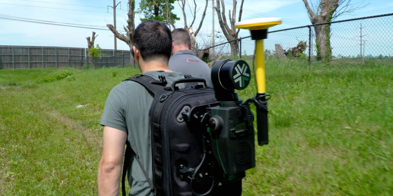
In many cases, surveying times can go from hours to minutes. Teams are able to stay safer and avoid hazardous environments. Best of all, because of the speed and ease of use, you can capture more often and capture larger areas, without the need to have expertly trained team members at each job site. Accurate, autonomous mobile mapping allows you to scale your surveying team by adding productivity and efficiency, not wasting time with frustrating re-work.
Drift is a common problem in mobile surveying where inaccuracies in the scan can start to accumulate during the capture due to "noise" present in internal sensors. Drift is inherent in all mobile surveying solutions, and it’s one of the early issues with SLAM units. Throughout our development with the ExynPak and now with Nexys, we’ve pioneered and expanded upon several key technologies that move our systems closer to zero to no drift through global accuracy, achieving sub-centimeter accuracy in a variety of challenging environments indoors and outdoors.
 GIF of a SLAM platform closing the loop
The most advantageous aspect of our anti-drift technology for you as a surveyor is that it’s all done internally within the Nexys. This either happens in real-time during the capture or automatically during post-processing on the included ruggedized tablet that ships with each platform. Survey teams can also post-process data through the Batch Post Processing app, which you can read more about here.
Here’s how each of these works:
When available, Nexys can automatically use GPS or GNSS signals when using compatible sensors such as the Trimble DA2. During the capture, global positioning data is captured in real-time and matched with the local data capture, then corrected accordingly. This correction can also occur during the post-processing, which can all be done onsite with no need to upload the files to another application.
Loop closure is a technique that surveyors can use whenever they capture a SLAM dataset. It's as simple as walking the Nexys unit past a previously scanned location from a different direction. As the Nexys unit returns to a previously captured area, it can automatically detect any drift that was accumulated and make corrections by comparing the two local captures for that specific location. You can think of this almost like a “double check” that takes place during the capture. 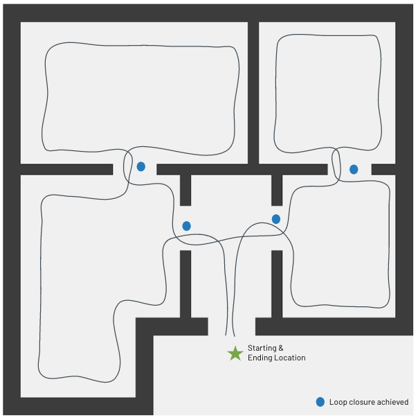
The loop closure calculations take place within the Nexys unit and require no inputs or extra processing by the operator.
Ground control points can be used to increase global accuracy. These can be existing control points from previous terrestrial scans, or can even be "shot in" right before a Nexys capture. When used, optional reflective markers are placed at these control points, and the Nexys automatically detects them and uses them in post-processed georeferencing to further constrain the map for global accuracy.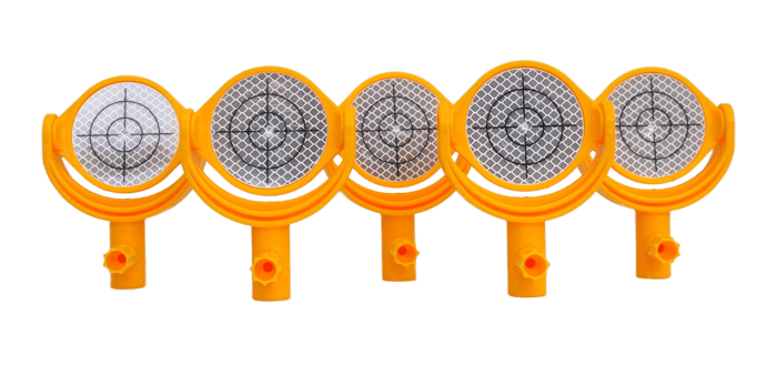
In post-processing, the final point cloud is aligned and corrected with the control point data automatically.
With Nexys, claims of accuracy are more than just marketing talk. Our post-processing system automatically provides accuracy reports when the process is complete. You can even download an accuracy report for Nexys here.
During the webinar, Lead Project Manager showed one of these accuracy reports from a real-world capture. The majority of the scans came in with an accuracy of 5mm or better. It was so impressive that a viewer even asked during the Q&A session if it was a misprint.
It’s a perfect example of how far mobile SLAM units like Nexys have come, both in terms of accuracy and the variety of use cases they handle.
If you want to learn more about Nexys and how to add mobile surveying to your team’s toolkit, make sure to watch our free webinar, which goes into further detail on all the topics covered above.
You can also contact us directly and set up a free, fully customized demo tailored to your surveying workflow and industry use cases.
