If you're a surveyor in the field, or the lead in charge of multiple ongoing projects, it can be difficult to track all the new advancements in geospatial mapping technology. And nowadays it feels like there are more tools capable of capturing more data than ever before. But what do these tools actually do? Do survey teams even need to collect all that data? Can artificial intelligence be useful in this application?
At Exyn, we sit at the intersection of high-accuracy mapping and unbounded autonomous exploration, so watching these trends comes with the territory. Here's a look at 5 evolving trends we're keeping top of mind to better inform our customers and partners.
Over the past decade, the technology that's available to survey teams across a variety of industries has greatly improved. To be fair, this work had historically consisted of hand drawn maps done from visual memory. Not exactly the most accurate solution! But as technology improved, surveyors were able to integrate other data points into their maps from photos and satellite information. And now with the advent of precise laser scanners, surveyors can take extremely accurate measurements using a tripod-based scanner, or even mounting laser scanners to fixed wing drones to capture large topographical data sets.
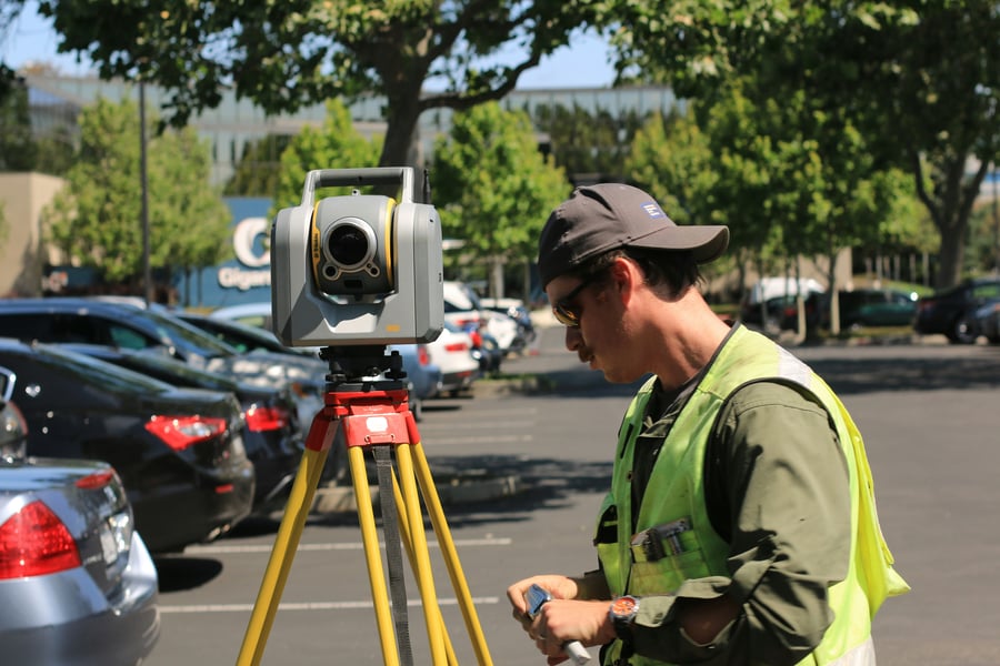 Surveyor/Engineer capturing data using a tripod-based laser scanner
However, even with these incredible new tools, surveyors still needed to solve their own "last mile" problem. Many of these tools are capable of capturing intricate and precise data points that require GPS coordinates, a prior map, or some kind of connection to WiFi or existing infrastructure in order to generate an accurate 3D model. The "last mile" data is often just as crucial to track progress while often being out of communications range or in a dangerous environment for the surveyor to walk through.
To capture that data, new autonomous drones have stepped up to pilot themselves into dangerous environments to capture intricate 3D models in a matter of minutes. These maps are captured through a process often called SLAM, or Simultaneous Localization And Mapping, which allows a robot to move through a space while mapping at the same time. This is much faster than using a tripod based laser scanner, but often is slightly less accurate.
But surveyors don't often need millimeter accuracy for every application, so when speed is key they can easily use a SLAM system. Then when a really precise measurement is needed they can bring out their terrestrial scanner. This expansion of the surveyor toolbox has made the job more efficient, less dangerous, and with less strain on workers in the field.
I know, AI or Artificial Intelligence is the new buzzword that everyone's throwing around to make their product sound more important than it actually is. But with that said, AI is helping survey teams create better 3D models, and it's because surveyors have access to more data than ever before.
To capture that data, survey teams can now use advanced autonomous drones to help them capture large data sets from inaccessible areas in the field. These drones use sophisticated artificial intelligence algorithms powered by a LiDAR-based SLAM software, like ExynAI, to autonomously navigate through an area of interest while creating a feature-rich 3D model. Currently, the AI enables the robot to detect static and dynamic obstacles, even for objects as thin as a wire, and safely navigate around it through a safe flight corridor.
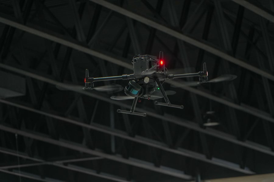 The ExynAero DJ34, an autonomous aerial robot for exploration and mapping
In addition to the advanced onboard AI, we've also been using machine learning to teach our navigational AI the difference between static points and dust that gets kicked up in the propeller downwash. This machine learning will enable our robots to reason about obstacles they encounter in the field, further improving their level of autonomy.
Artificial Intelligence and Machine Learning can also be a boon for survey teams when autonomous systems aren't flying or mapping around. Once the robot doesn't have to worry about autonomous control, it can focus all its computational resources on refining and improving the quality of the 3D model it just collected. This is most commonly referred to as Offline SLAM, which you can read more about here. But broadly, offline SLAM uses AI to clean up any errant points captured in the map.
One of the ways we've used AI in offline SLAM for ExynAI is by eliminating non-static points through our post processing pipeline. This 'ghosting' happens when a person or object walks through an area being captured by a mobile SLAM platform. Since the platform is capturing and maintaining all of the points while live, LiDAR returns that bounced off of a person can be seen in a path through the model, like a ghost. We've trained our AI to detect these ghost paths and eliminate them through post processing. This is an important step for our customers to clean their 3D models before importing them into downstream software.
In addition to AI, you might have heard the term "edge computing" being thrown around more recently. It's just a fancy way of saying you can process data in the field without needing to upload it to a cloud or other service. Being able to compute "on the edge" aka "in the field." This is especially important for survey teams working in remote locations but is still vital across industries to ensure a proper 3D model was captured before uploading a large data set for processing. It wastes time, delays projects, and frustrates an already busy team of surveyors.
The main issue is, the files you capture through a SLAM platform or similar are a huge computational load to process! For a SLAM algorithm to process the data it captured into a usable 3D model, it sort of retraces the steps it performed during the scan and uses complex math to identify unique features in its environment to properly orient and scale the model to be as locally accurate as possible. It's not like a surveyor can carry around a supercomputer in their truck, so this kind of computation has traditionally been sent into the cloud.
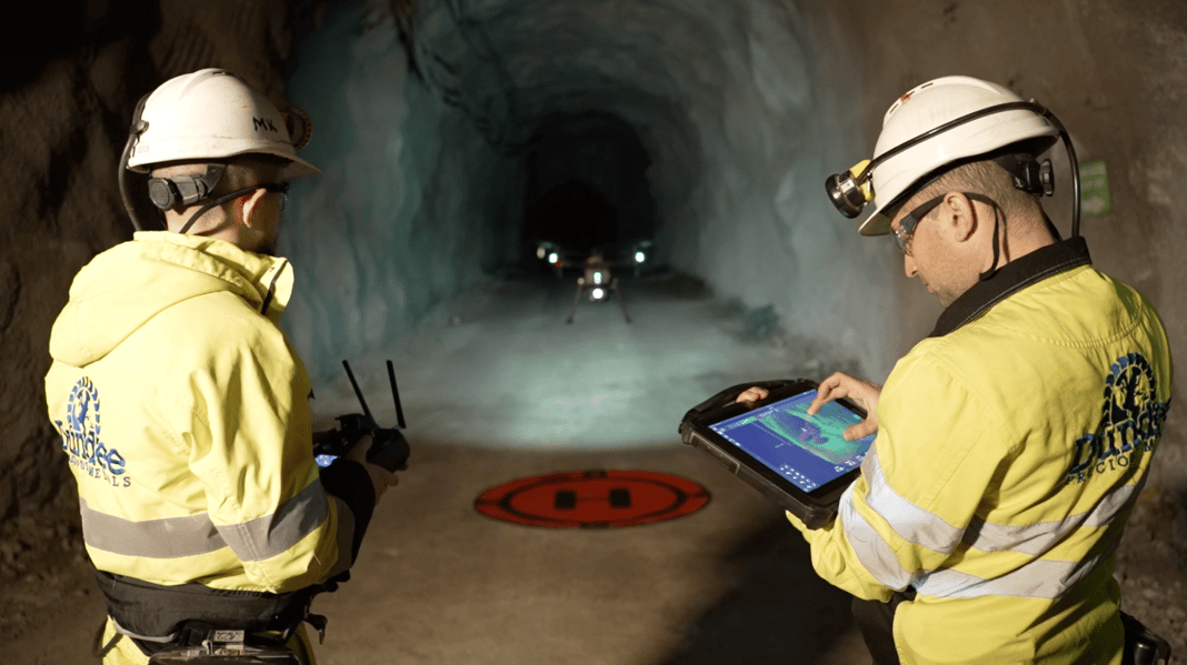 Two mining surveyors launching the ExynAero on a mission via ruggedized tablet
However, new ruggedized hardware for field use has been catching up in terms of raw power which can now process and view point clouds to ensure the job is done before leaving the site. For surveyors using ExynView, they can even smooth, downsample, and even geo-reference point clouds directly through our ruggedized tablet. And until we can send autonomous robots a long distance into unknown terrain, human surveyors will continue to compute on the edge.
In the event of a natural disaster or infrastructure failure, creating an accurate 3D model of current conditions that first responders can assess and use for planning is crucial in the first few hours. We've seen more recently that some small vision-equipped drone platforms have been used successfully to capture real-time video of a disaster response. When an apartment complex in Florida collapsed due to structural issues, emergency teams were quickly able to create a colorized 3D model using a vision-powered drone.
A search & rescue application using the ExynAero in an underground mine
These are great tools! But they do require proper lighting and flying conditions to operate successfully and safely. When situations aren't perfect, first responders can usually use a tool like a portable 3D scanner, like the Nexys, either by hand, mounted to a drone, or a ground-based robot to map an entire area of interest. For example, if an incident were to happen in an underground mine a LiDAR-based SLAM system could be very useful in capturing a complete 3D model that first responders could use to determine the safest points of entry to search for any potential survivors. SLAM also has the power of integrating other sensors into its pipeline, so in the future first responders could build a real-time 3D map with data overlays of gas and chemical readings for even more situational awareness.
For the past decade, surveying technology has been in the game of "chasing millimeters" in order to create the most accurate digital twins of construction projects and ongoing work for evaluation and inspection. As we've mentioned in this article, tripod-based laser scanners have been the go-to tool for capturing that level of detail. But as technologies improve we're discovering that you don't always need millimeter level measurements for every single survey application on a job site.
More recently, technologies like photogrammetry and SLAM have made capturing and processing digital twins much more accurate and efficient. So rather than going through the tedious process of using a tripod-based laser scanner to measure a building that's going to be demolished for a new structure, survey teams could quickly map it with a portable SLAM platform to generate a 3D model. The same process can be used after demolition to set a baseline for the architects to construct in their BIM model. These digital twins can be captured and processed in a matter of minutes instead of hours or sometimes even days, reducing downtime on site.
So now instead of chasing millimeters, surveyors can quickly and efficiently capture feature rich 3D models using a variety of portable laser scanners thanks to advancements in SLAM mapping algorithms.
To see how a modular, portable, LiDAR-based laser scanner like the Nexys could level up your surveying workflows you can request a personalized demo or get in touch with us to learn more.
