---
title: Nexys Purchase Options | Exyn
description: Purchase options are as configurable as the Nexys itself, so we recommend a brief consultation with our team to design the best plan for your business.
image: https://www.exyn.com/hubfs/exyn-logo_horiz-white.svg
---
[ ](https://www.exyn.com/?hsLang=en)
[](https://cta-redirect.hubspot.com/cta/redirect/8300473/57396f92-3fbc-42c5-bbd2-fbf6fcbf28fe)
[](https://cta-redirect.hubspot.com/cta/redirect/8300473/57396f92-3fbc-42c5-bbd2-fbf6fcbf28fe)
  
# Exyn Nexys
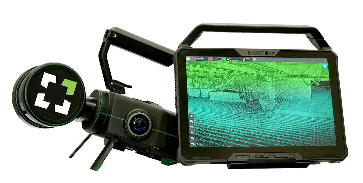
Exyn offers a variety of packages and contract options for the Nexys from one to three years to meet your applications and goals.
Purchasing options are as configurable as the Nexys itself, so we recommend a brief consultation with our team to design the best plan for your business.
[ Book a Demo ](https://cta-service-cms2.hubspot.com/web-interactives/public/v1/track/click?encryptedPayload=AVxigLLty2nph278fYyW6Go1HdK6TlhD9gGcAsDWA1S2JA1ovKfJP1kwVjquNca0EoM7594sP5AK0MA0lJIZnP3FP%2BV4Uf20jZQTq5BT2ZGlGPCrW4xyXDbJFnToPUp%2FgMdo%2Fkf8zr7MTk0NdzChKE5Okkbl42KJhLgw%2Bs8zsFQ%3D&portalId=8300473)
[Download Spec Sheet](https://www.exyn.com/nexys-pro-product-sheet?hsLang=en)
**
## Choice of LiDAR Sensor
Nexys Nexys Pro
### Features
Points Per Second
~600,000
~1,280,000
Maximum Range
100 m @ 80% surface reflection
300 m @ 80% surface reflection
Return Type
Dual with Intensity
Triple with Intensity
Range Accuracy
Up to ± 1cm
Up to ± 1cm
Point Cloud Colorization
**
**
   
## Standard Mapping Package
### The **Exyn Nexys** comes out of the box with a **Standard Mapping Package** ready to capture accurate, colorized point cloud maps that can be quickly exported and georeferenced on site.
[
Real Time Data Visualization
Real-time visualization of your captured data with full detail and colorization in the field to ensure the scan area is correct and complete before you leave the site. ](https://www.exyn.com/?hsLang=en) [
Fast Data Capture
Nexys’ SLAM-based spatial mapping is capable of capturing up to 1.92 million scan points per second, while continuously updating the map as new data is received. ](https://www.exyn.com/?hsLang=en) [
ExynView Software
Controls for capture and post processing in the same system, allowing for fast on premise processing for more streamlined workflows. ](https://www.exyn.com/?hsLang=en) [
Survey Grade data accuracy
Nexys delivers consistent and repeatable survey grade accuracy of up to 1cm @ 1 sigma dependent on the environment. ](https://www.exyn.com/?hsLang=en) [
Built for Rugged Environments
The highest protection against water and solid ingresses, such as windblown dirt and other airborne solid materials, as well as water hoses, jet sprays, and momentary water immersion. Guaranteed to function in indoor, outdoor, wet, and demanding industrial and commercial settings. ](https://www.exyn.com/?hsLang=en) [
Works in Comms-Denied Environments
All required intelligence is onboard for reliable flight in communications-denied environments. Data is collected onboard and streamed back to the user once back in range of communications. ](https://www.exyn.com/?hsLang=en) [
Real Time Colorization
Derive additional insights from point clouds with accurate colorization visualization at no additional cost. ](https://www.exyn.com/?hsLang=en) [
360º Colorization Coverage
Hemispherical cameras cover 100% of the field of view of the LIDAR making it easier to generate fully colorized clouds without any additional hardware or cost. ](https://www.exyn.com/?hsLang=en)

## Additional Autonomy Packages
Multiple autonomy packages are available for customers in need of capturing rich point clouds of impossible to reach areas.
Aerial Autonomy
### Aerial Autonomy
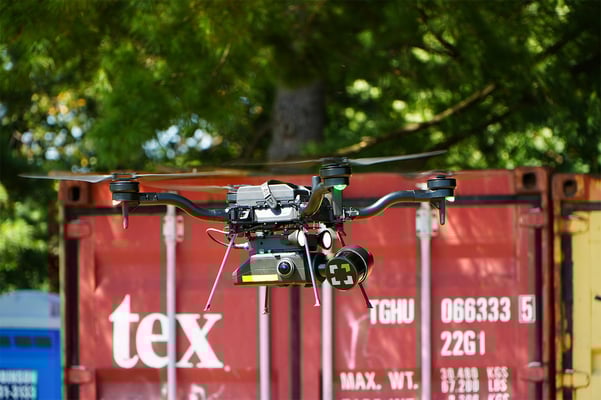
Adding an aerial autonomy license opens up a whole new world of 3D spatial mapping. This package comes with the Drone Link accessory to integrate Nexys onto approved robotic airframes. The autonomy package comes with all the features from the Standard Mapping Package, plus:
**Fully Autonomous LiDAR Mapping & Navigation** - Proprietary autonomy algorithms, coupled with SLAM-based LiDAR scanning technology deliver survey-grade results without a pilot. The operator simply sets the area to scan and the system determines its own route to ensure complete environmental coverage, detects the 3D environment, and identifies and reasons about obstacles and high-level objectives - even in GPS-denied, hazardous, and unilluminated environments.
**Fly-To Mission Mode** - The fly-to objective defines a location in space that the robot will try to get to best effort. The robot employs advanced path planning to try and reach the desired location which allows the robot to embark on indirect routes to achieve the objective. This objective is combined with a goal success radius that will allow the placement of the objective to be less sensitive as the robot only needs to get within a certain distance of a XYZ location. If the robot determines that the precise location is inaccessible due to placement in a object or blocked by an obstacle, the objective will be failed and the robot will either return home or to the next programmed objective depending on the mission parameters.
**Volumetric Exploration Mission Mode** - The volumetric exploration objective is defined as a 3D bounding box of where the user wants to map. The robot employs a frontier based exploration algorithm to maximize LIDAR coverage within the environment thus minimizing shadows and blind spots. The algorithm is robust enough to solve a complex maze should a bounding box be placed around it. Once the robot has seen as much as it can within the bounding box or if a contingency policy is evoked (such as low battery), the robot will return home safely with the data is hand.
**Planar Inspection Mission Mode** - The planar inspection mission mode is designed for low FOV sensors, such as EO cameras, to collect 100% coverage data on a surface. The inspection plane is defined in the user interface and multiple planes can be sequenced in series to inspect multiple assets / wall / rows / etc.
**Battery Aware Return to Home (RTH)** - Built in health monitoring always ensures that the robot can get back to home with the available battery reducing the cognitive burden on the operator.
Ground Autonomy
### Ground Autonomy
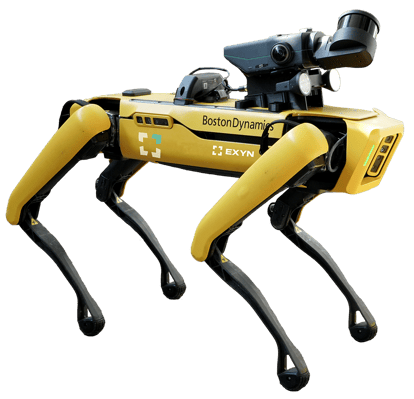
The ground autonomy package for Nexys enables survey teams to explore and map complex environments using an autonomous four-legged robot like Spot, from Boston Dynamics. This package comes with the Drone Link accessory to integrate Nexys onto approved robotic platforms. The ground autonomy package comes with all the features from the Standard Mapping Package, plus:
**Fully Autonomous LiDAR Mapping & Navigation** - Proprietary autonomy algorithms, coupled with SLAM-based LiDAR mapping technology deliver survey-grade results without an operator in the loop. Simply set the area to scan and the system determines its own route to ensure complete environmental coverage, detects the 3D environment, and identifies and reasons about obstacles and high-level objectives -- even in GPS-denied, hazardous, and unilluminated environments.
**Walk-There Mission Mode** - The walk-there mission mode defines a location in space that the robot will try to get to. The robot employs advanced path planning to try and reach the desired location which allows the robot to embark on indirect routes to achieve the objective if an obstacle is in the way. This objective is combined with a goal success radius that will allow the placement of the objective to be less sensitive as the robot only needs to get within a certain distance of a XYZ location. If the robot determines that the precise location is inaccessible due to placement in a object or blocked by an obstacle, the objective will be failed and the robot will either return home or to the next programmed objective depending on the mission parameters.
**Volumetric Exploration Mission Mode** - The volumetric exploration objective is defined as a 3D bounding box of where the user wants to map. The robot employs a frontier-based exploration algorithm to maximize LIDAR coverage within the environment thus minimizing shadows and blind spots. The algorithm is robust enough to solve a complex maze should a bounding box be placed around it. Once the robot has seen as much as it can within the bounding box or if a contingency policy is evoked (such as low battery), the robot will return home safely with the data is hand.
**Battery Aware Return to Home (RTH)** - Built in health monitoring always ensures that the robot can get back to home with the available battery, reducing the cognitive burden on the operator.
### Aerial Autonomy

Adding an aerial autonomy license opens up a whole new world of 3D spatial mapping. This package comes with the Drone Link accessory to integrate Nexys onto approved robotic airframes. The autonomy package comes with all the features from the Standard Mapping Package, plus:
**Fully Autonomous LiDAR Mapping & Navigation** - Proprietary autonomy algorithms, coupled with SLAM-based LiDAR scanning technology deliver survey-grade results without a pilot. The operator simply sets the area to scan and the system determines its own route to ensure complete environmental coverage, detects the 3D environment, and identifies and reasons about obstacles and high-level objectives - even in GPS-denied, hazardous, and unilluminated environments.
**Fly-To Mission Mode** - The fly-to objective defines a location in space that the robot will try to get to best effort. The robot employs advanced path planning to try and reach the desired location which allows the robot to embark on indirect routes to achieve the objective. This objective is combined with a goal success radius that will allow the placement of the objective to be less sensitive as the robot only needs to get within a certain distance of a XYZ location. If the robot determines that the precise location is inaccessible due to placement in a object or blocked by an obstacle, the objective will be failed and the robot will either return home or to the next programmed objective depending on the mission parameters.
**Volumetric Exploration Mission Mode** - The volumetric exploration objective is defined as a 3D bounding box of where the user wants to map. The robot employs a frontier based exploration algorithm to maximize LIDAR coverage within the environment thus minimizing shadows and blind spots. The algorithm is robust enough to solve a complex maze should a bounding box be placed around it. Once the robot has seen as much as it can within the bounding box or if a contingency policy is evoked (such as low battery), the robot will return home safely with the data is hand.
**Planar Inspection Mission Mode** - The planar inspection mission mode is designed for low FOV sensors, such as EO cameras, to collect 100% coverage data on a surface. The inspection plane is defined in the user interface and multiple planes can be sequenced in series to inspect multiple assets / wall / rows / etc.
**Battery Aware Return to Home (RTH)** - Built in health monitoring always ensures that the robot can get back to home with the available battery reducing the cognitive burden on the operator.
### Ground Autonomy

The ground autonomy package for Nexys enables survey teams to explore and map complex environments using an autonomous four-legged robot like Spot, from Boston Dynamics. This package comes with the Drone Link accessory to integrate Nexys onto approved robotic platforms. The ground autonomy package comes with all the features from the Standard Mapping Package, plus:
**Fully Autonomous LiDAR Mapping & Navigation** - Proprietary autonomy algorithms, coupled with SLAM-based LiDAR mapping technology deliver survey-grade results without an operator in the loop. Simply set the area to scan and the system determines its own route to ensure complete environmental coverage, detects the 3D environment, and identifies and reasons about obstacles and high-level objectives -- even in GPS-denied, hazardous, and unilluminated environments.
**Walk-There Mission Mode** - The walk-there mission mode defines a location in space that the robot will try to get to. The robot employs advanced path planning to try and reach the desired location which allows the robot to embark on indirect routes to achieve the objective if an obstacle is in the way. This objective is combined with a goal success radius that will allow the placement of the objective to be less sensitive as the robot only needs to get within a certain distance of a XYZ location. If the robot determines that the precise location is inaccessible due to placement in a object or blocked by an obstacle, the objective will be failed and the robot will either return home or to the next programmed objective depending on the mission parameters.
**Volumetric Exploration Mission Mode** - The volumetric exploration objective is defined as a 3D bounding box of where the user wants to map. The robot employs a frontier-based exploration algorithm to maximize LIDAR coverage within the environment thus minimizing shadows and blind spots. The algorithm is robust enough to solve a complex maze should a bounding box be placed around it. Once the robot has seen as much as it can within the bounding box or if a contingency policy is evoked (such as low battery), the robot will return home safely with the data is hand.
**Battery Aware Return to Home (RTH)** - Built in health monitoring always ensures that the robot can get back to home with the available battery, reducing the cognitive burden on the operator.

## Light & Powerful Ruggedized Tablet
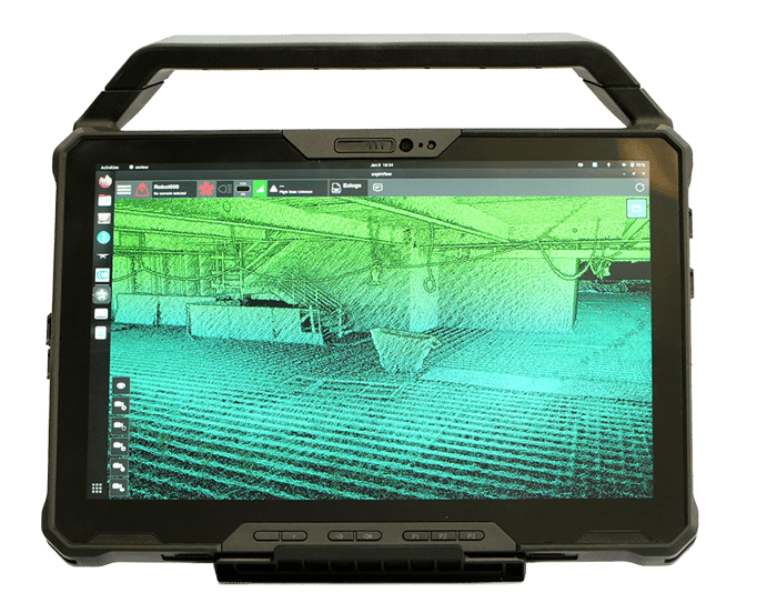
The Nexys comes paired with a ruggedized Dell Latitude tablet for easy mission planning for autonomous aerial exploration missions, or for monitoring the real-time status of a mobile mapping 3D capture - making mobile surveying simple, efficient, and accurate.
[Explore ExynView](https://www.exyn.com/exynview-software?hsLang=en)
## [Additional Accessories](https://www.exyn.com/nexys-accessories?hsLang=en)
Included with standard mapping package Vehicle-Mount Easily and securely mount Nexys to almost any vehicle or surface, allowing you to capture a complete map in rugged environments.
Sold separately BackPack-Mount Our ruggedized, water resistant backpack holds and powers Nexys while scanning, and also serves as a storage and travel case.
Included with Autonomy License Drone Link The hardware interface between the drone and Nexys for manually piloted operation or autonomous flight (with autonomy license)
Sold Separately GPS Module Dongle that can be mounted to Nexys to add GPS data to post-processing algorithm, reducing drift in longer captures.
sold separately Protective Cage A cage which provides 360° protection in challenging environments like vertical shafts
SOLD SEPARATELY Trimble DA-2 The Trimble DA2 seamlessly pairs with Nexys to further reduce accumulated drift in long scans with precise GPS data.
sold separatley Boom-Mount For more simple mapping missions, Nexys operators can mount the payload to a boom for entry into a cavity or other area of interest.
Sold separatley 360° Camera Accessory A mount for handheld/backpack captures which collects 4K inspection-ready imagery and geometry.

Copyright © 2026 Exyn Technologies
[(215) 999-0200](tel:+1%20215%20999-0200)
[Contact Us](https://www.exyn.com/about/contact?hsLang=en) [Do Not Sell or Share My Personal Information](https://www.exyn.com/purchase#) [ Data Privacy Rights Form](https://my.datasubject.com/AzqgT7Th06O5n7f37/26903)